![](/images/other/stat-length.png)
![Tour Skiwanderen Le Haut-Bréda - Belle Etoile et Pic des Cabottes couloir S - Photo](https://media.geolcdn.com/t/1900/400/3f446dca-8587-476b-b4f9-492466f114e8.jpg&format=pjpeg&maxdim=2)
Belle Etoile et Pic des Cabottes couloir S
nadd73
Benutzer GUIDE
![Länge](/images/other/stat-length.png)
![Maximale Höhe](https://static1.geolcdn.com/siteimages/upload/files/1508320355ic_sort_altitude_max_24dp.png)
![Positive Höhendifferenz](https://static1.geolcdn.com/siteimages/upload/files/1508320355ic_sort_den_pos_24dp.png)
![Km-Effort](/images/other/stat-length.png)
![Min. Höhe](https://static1.geolcdn.com/siteimages/upload/files/1508320355ic_sort_altitude_min_24dp.png)
![Negative Höhendifferenz](https://static1.geolcdn.com/siteimages/upload/files/1508320355ic_sort_den_neg_24dp.png)
![Boucle](https://static1.geolcdn.com/siteimages/upload/files/16400158638029165_repeat_loop_refresh_sync_direction_icon.png)
![Skiwanderen](https://static1.geolcdn.com/sitytour/trail-icons/503.png)
8h04
Schwierigkeit : Sehr schwierig
![Scannen Sie diesen QR-Code, um die Tour in der SityTrail-Anwendung zu öffnen](https://capi.geolives.com/qq0zvz2zws4bq2lad0pu/sitytour/trails/2755616/qr.png?size=200)
Kostenlosegpshiking-Anwendung
Über SityTrail
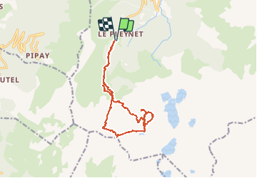
Tour Skiwanderen von 15,7 km verfügbar auf Auvergne-Rhone-Alpen, Isère, Le Haut-Bréda. Diese Tour wird von nadd73 vorgeschlagen.
Beschreibung
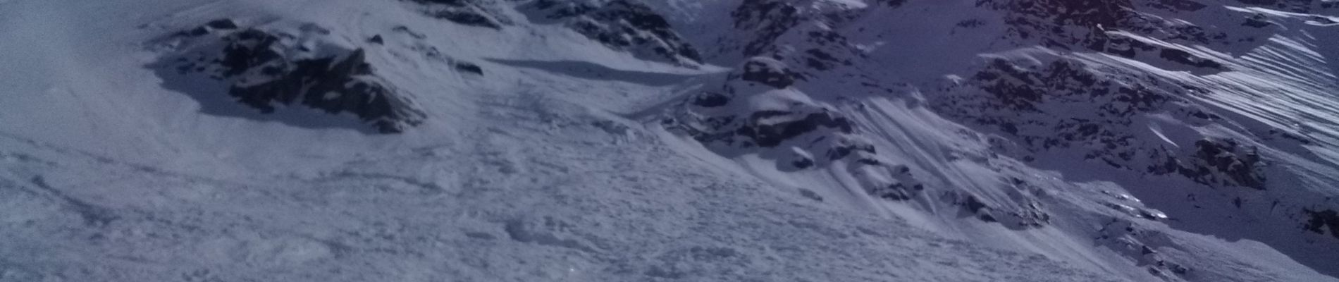
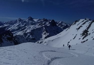
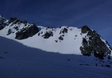
Du pleynet, monter à la belle étoile, Descente Est en traversée et au dessus du lac de la belle étoile, je suis montée mais impossible de poursuivre trop risqué. Ensuite j'ai vu une trace de montée aux Cabottes. A 2500 j'ai voulu faire le tour du pic des Cabottes mais très raide et barres en dessous.
Donc sommet avec la fin arête fine, donc crampons. Et comme le couloir commence raide 45 degrés je descends le plus raide en crampons
Ort
Kommentare
Touren in der Umgebung
![Tour Wandern Le Haut-Bréda - Lac Blanc Lac de la Folle - Photo](https://media.geolcdn.com/t/375/260/f4e38b80-48fc-49d4-b675-d255436e858e.jpg&format=jpg&maxdim=2)
![Wandern Wandern](https://static1.geolcdn.com/sitytour/trail-icons/101.png)
Wandern
![](/images/other/stat-length.png)
![](https://static1.geolcdn.com/siteimages/upload/files/16400158638029165_repeat_loop_refresh_sync_direction_icon.png)
![Tour Wandern Les Adrets - les 7 laux - Photo](https://media.geolcdn.com/t/375/260/ext.jpg?maxdim=2&url=https%3A%2F%2Fservices.sitytrail.com%2FGeolivesWS%2FDownloadMedia.ashx%3FTrailID%3D210621%26Media%3Dfix__20130806134428.jpg)
![Wandern Wandern](https://static1.geolcdn.com/sitytour/trail-icons/101.png)
Wandern
![](/images/other/stat-length.png)
![](https://static1.geolcdn.com/siteimages/upload/files/16400158638029165_repeat_loop_refresh_sync_direction_icon.png)
![Tour Wandern Le Haut-Bréda - Combe du Prat - Photo](https://media.geolcdn.com/t/375/260/6714bc1b-1337-4dda-8a6e-4ad571484b33.jpg&format=jpg&maxdim=2)
![Wandern Wandern](https://static1.geolcdn.com/sitytour/trail-icons/101.png)
Wandern
![](/images/other/stat-length.png)
![](https://static1.geolcdn.com/siteimages/upload/files/16400158638029165_repeat_loop_refresh_sync_direction_icon.png)
![Tour Skiwanderen Les Adrets - le jas de lièvre et vol de Bédina - Photo](https://media.geolcdn.com/t/375/260/fb6d4008-e294-44a8-86f0-b378b0a893a8.jpg&format=jpg&maxdim=2)
![Skiwanderen Skiwanderen](https://static1.geolcdn.com/sitytour/trail-icons/503.png)
Skiwanderen
![](/images/other/stat-length.png)
![](https://static1.geolcdn.com/siteimages/upload/files/16400158638029165_repeat_loop_refresh_sync_direction_icon.png)
![Tour Skiwanderen Laval-en-Belledonne - col du Rafour et couloir ouest de la montagne de Barlet - Photo](https://media.geolcdn.com/t/375/260/93573ad3-540b-4442-acb2-432d15b1a0ec.jpg&format=jpg&maxdim=2)
![Skiwanderen Skiwanderen](https://static1.geolcdn.com/sitytour/trail-icons/503.png)
Skiwanderen
![](/images/other/stat-length.png)
![](https://static1.geolcdn.com/siteimages/upload/files/16400158638029165_repeat_loop_refresh_sync_direction_icon.png)
![Tour Skiwanderen Laval-en-Belledonne - la dent du Pra par le col de l'Aigleton - Photo](https://media.geolcdn.com/t/375/260/35f172bb-b4cf-4c46-abfa-0c6386b3c585.jpg&format=jpg&maxdim=2)
![Skiwanderen Skiwanderen](https://static1.geolcdn.com/sitytour/trail-icons/503.png)
Skiwanderen
![](/images/other/stat-length.png)
![](https://static1.geolcdn.com/siteimages/upload/files/16400158638029165_repeat_loop_refresh_sync_direction_icon.png)
![Tour Skiwanderen Laval-en-Belledonne - couloir Est du sifflet et pas du pin par couloir ouest - Photo](https://media.geolcdn.com/t/375/260/923162f4-fc60-40a4-900d-69278daa194d.jpg&format=jpg&maxdim=2)
![Skiwanderen Skiwanderen](https://static1.geolcdn.com/sitytour/trail-icons/503.png)
Skiwanderen
![](/images/other/stat-length.png)
![](https://static1.geolcdn.com/siteimages/upload/files/16400158638029165_repeat_loop_refresh_sync_direction_icon.png)
![Tour Mountainbike Theys - Autour du crêt de Chazay - Photo](https://media.geolcdn.com/t/375/260/ext.jpg?maxdim=2&url=https%3A%2F%2Fstatic1.geolcdn.com%2Fsiteimages%2Fupload%2Ffiles%2F1524743154velo.jpg)
![Mountainbike Mountainbike](https://static1.geolcdn.com/sitytour/trail-icons/202.png)
Mountainbike
![](/images/other/stat-length.png)
![](https://static1.geolcdn.com/siteimages/upload/files/16400158638029165_repeat_loop_refresh_sync_direction_icon.png)
![Tour Wandern Le Haut-Bréda - Les lacs sept Claux - Photo](https://media.geolcdn.com/t/375/260/ab2c771e-7afd-4d71-bf80-bad543cd1a27.jpg&format=jpg&maxdim=2)
![Wandern Wandern](https://static1.geolcdn.com/sitytour/trail-icons/101.png)
Wandern
![](/images/other/stat-length.png)
![](https://static1.geolcdn.com/siteimages/upload/files/16400158638029165_repeat_loop_refresh_sync_direction_icon.png)